River Mountains Loop Trail

Facebook icon

  • Home
  • About
  • Trailheads and Maps
    • Trailheads in Boulder City
    • Trailheads in Henderson
    • Trailheads in Lake Mead NRA
  • History
    • Geology of the River Mountains
    • A -Desert Tortoise – Do’s & Dont’s
    • Keep It Clean
  • Blog
    • Recently on Facebook
  • Contact
    • Contact List
  • Donate

New Trail Website

Full color map of the River Mountains Loop Trail on the new trail website.
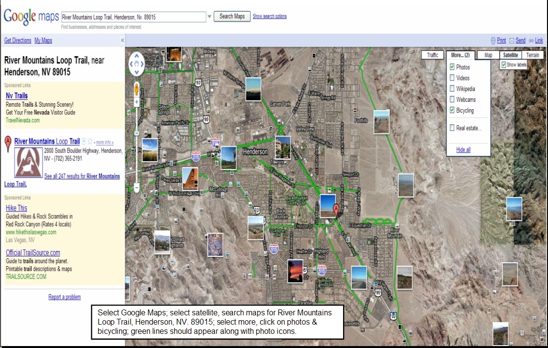
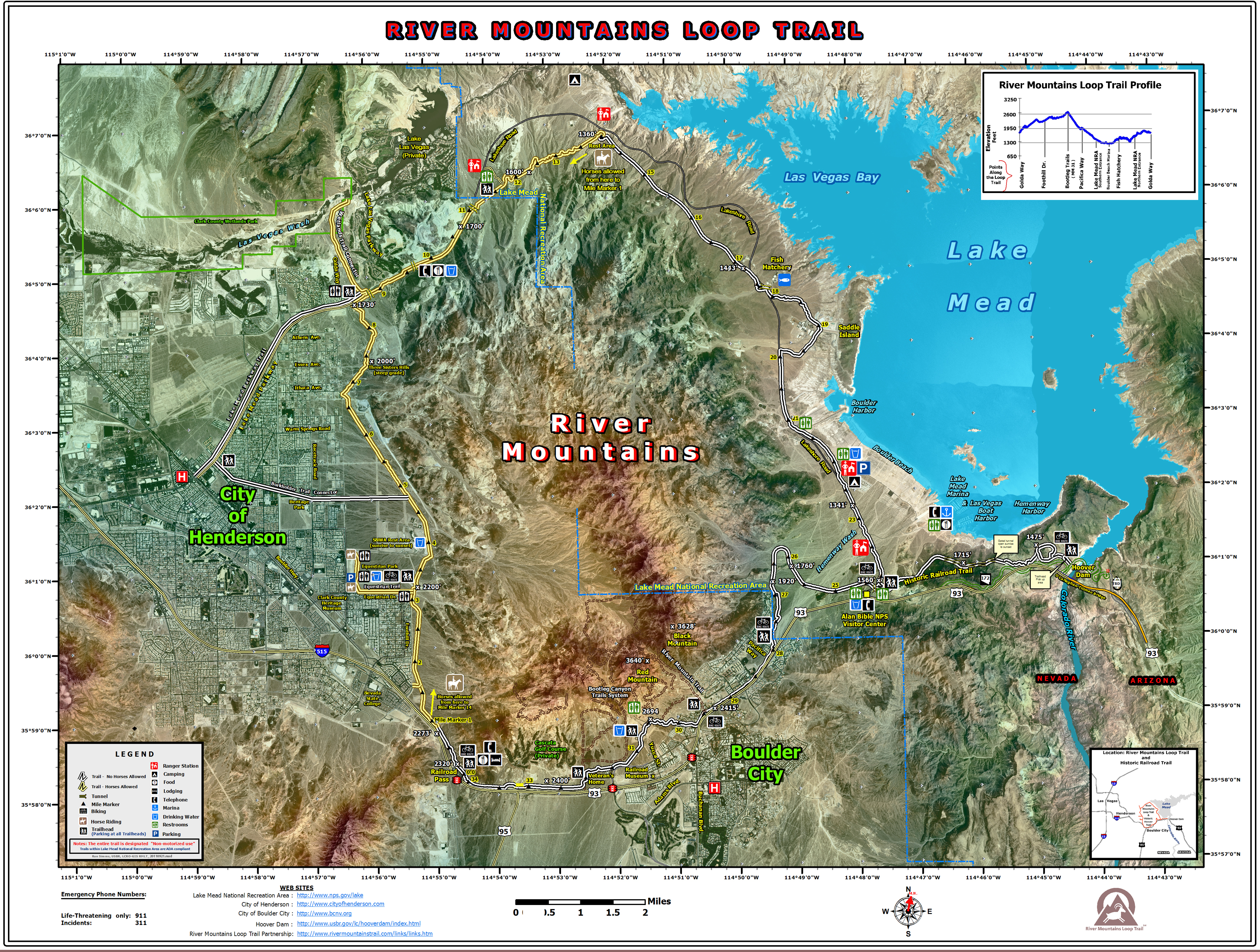
Yes the new trail website for River Mountains Loop Trail is finally here. Users have been asking for a fresher more interactive web site. The new site brings together Facebook, Blogging and web information all in one.  Maps and trail heads was a key part of the new design. Working with our web creator, Steve Rypka of GreenDreamWeb, we were able to give you all our current maps and create trail head information including photos of each and Google Maps to find your way. Thank you Steve.

Photos play a key part in telling the trail story so keep your eyes open for new photos from the editor and fans who post their adventures along the River Mountains Loop Trail.

We wish all ” Happy Trails” and many of them.

Your web design team….

Bicycling Routes, Lanes, Trails on Google Maps “How to Find”

April 2010 – How do I find the River Mountains Loop Trail?  Where are the trail heads? Where are there connecting trails and bike routes or lanes?  Where can I see photos taken along the trail? Google Maps has the answer.  I have enclosed a power point presentation which hopefully walks you through the process.  It is still a work in progress, but it gets you out there on the trail.  Once you master this you can go anywhere across the country and try it out.

Step one:  get to Google and select Google Maps.  Step Two: Select Satellite (my preference)  Step three: search maps for ‘River Mountains Loop Trail, Henderson, Nv. 89015’    Step four:  select more and on the drop down menu click on photos & bicycling; green lines should appear indicating trails and bike routes along with photo icons.

Now the fun begins. To view the photos, place your cursor over a photo and click; photo opens with title and owner; click on by nevhiker(owner) or view in Panoramio to see larger photo and more…

Trail Heads:  To find trailheads and other points of interest go to the “New” button in green, click and a drop down of new features appears; scroll down and enable “What’s Around Here?” Little dots and buttons appear along with a listing down the left side of your screen.  you can move around the map and along the green trail and different points of interest and trail heads will appear.  click on a lettered button or a round dot to see what is there. The example in the Powerpoint (slide three) shows trail head information for “Historic Railroad & River Mountains Loop Trailhead“.  From this pop up you can get directions, link to web site, read reviews or write them, plus get additional information(slide 4).

Finally try it out and experiment  on your own and enjoy.  It is a great trail tool. Reminder Google is Beta testing this feature so it could change at anytime or even just go away.

Link  Powerpoint:  RMLT google maps – trails-bicyling march 2010

Google maps Bike Routes & Trails

River Mountains Loop Trail now found on Traillink.com

October 6, 2009 – We can now be found on traillink.com a map and trail location service provided by Rails-to-Trails Conservancy.  A good three and half miles of the RMLT are built on Historic Railroad bed within Lake Mead NRA. Also the RMLT links up with the official Historic Railroad Trail at the Alan Bible Visitor Center where a joint trail head is shared by both trails.  By riding or hiking these two trail sections you can experience 7.5 miles of the old railroad grade used to build Hoover Dam.  So please look for us at www.Traillink.com  feel free to post comments and photos there.

Mapmyride.com route for River Mountains Loop Trail – Miles & Elevation

September 30, 2009 – The following information comes from mapmyride.com and was recently provided to me to answer two questions other users had.  Since this GPS route was uploaded additional trail segments have been completed, but it does give a fairly accurate feel for route, distance, and elevation gain.  Enjoy and happy riding….

  1. What is the distance around the loop?   34.22 miles
  2. What is the total elevation gain around the loop? 1558 ft.

Link to map and additional information:

“http://js.mapmyfitness.com/embed/blogview.html?r=f8f5e75deec464b3b25c02bfc48eb551&u=e&t=ride“

Recent Blog Posts

Dogs on the Trail

Las Vegas Hiking Trail Featured in Article

Las Vegas Hiking Trail Featured in Article

Pacifica trail head Boulder City on the new trail website.

New Trail Website

Be Sure to Visit

Latest Posts on Facebook

Comments Box SVG iconsUsed for the like, share, comment, and reaction icons
Author Avatar
River Mountains Loop Trail
2 weeks ago
Come and join us on

Come and join us on March 14th! ... See MoreSee Less

View on Facebook
· Share
Share on Facebook Share on Twitter Share on Linked In Share by Email
View Comments likes 3 Shares: 0 Comments: 0

0 CommentsComment on Facebook

Author Avatar
River Mountains Loop Trail
4 weeks ago

Love our trail! ... See MoreSee Less

View on Facebook
· Share
Share on Facebook Share on Twitter Share on Linked In Share by Email
View Comments likes love 6 Shares: 1 Comments: 3

3 CommentsComment on Facebook

Author Avatar
River Mountains Loop Trail
1 month ago

FYI... For those who ride and hike Historic railroad trail....

... See MoreSee Less

Link thumbnail

Grant for erosion repairs will improve Historic Railroad Trail at Lake Mead

www.msn.com

A $250,000 grant from the James M. Cox Foundation, the charitable arm of Cox Enterprises, will support erosion repairs for the Historic Railroad Trail near Lake Mead.
View on Facebook
· Share
Share on Facebook Share on Twitter Share on Linked In Share by Email
View Comments likes 11 Shares: 0 Comments: 0

0 CommentsComment on Facebook

Load more

View Full-Sized