River Mountains Loop Trail

River Mountains Loop Trail Facebook Page
  • Home
  • About
  • Trailheads and Maps
    • Trailheads in Boulder City
    • Trailheads in Henderson
    • Trailheads in Lake Mead NRA
  • History
    • Geology of the River Mountains
    • A -Desert Tortoise – Do’s & Dont’s
    • Keep It Clean
  • Blog
    • Recently on Facebook
  • Contact
    • Contact List
You are here: Home / Biking / Bicycling Routes, Lanes, Trails on Google Maps “How to Find”

04/06/2010 by Editor

Bicycling Routes, Lanes, Trails on Google Maps “How to Find”

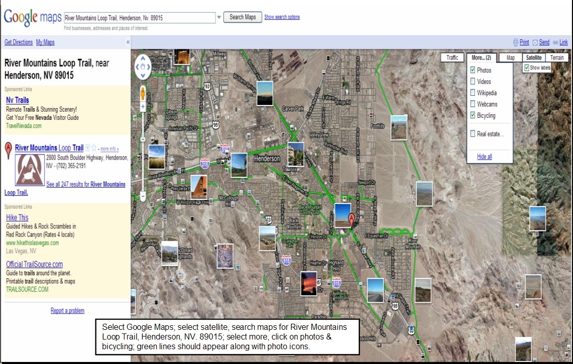
April 2010 – How do I find the River Mountains Loop Trail?  Where are the trail heads? Where are there connecting trails and bike routes or lanes?  Where can I see photos taken along the trail? Google Maps has the answer.  I have enclosed a power point presentation which hopefully walks you through the process.  It is still a work in progress, but it gets you out there on the trail.  Once you master this you can go anywhere across the country and try it out.

Step one:  get to Google and select Google Maps.  Step Two: Select Satellite (my preference)  Step three: search maps for ‘River Mountains Loop Trail, Henderson, Nv. 89015’    Step four:  select more and on the drop down menu click on photos & bicycling; green lines should appear indicating trails and bike routes along with photo icons.

Now the fun begins. To view the photos, place your cursor over a photo and click; photo opens with title and owner; click on by nevhiker(owner) or view in Panoramio to see larger photo and more…

Trail Heads:  To find trailheads and other points of interest go to the “New” button in green, click and a drop down of new features appears; scroll down and enable “What’s Around Here?” Little dots and buttons appear along with a listing down the left side of your screen.  you can move around the map and along the green trail and different points of interest and trail heads will appear.  click on a lettered button or a round dot to see what is there. The example in the Powerpoint (slide three) shows trail head information for “Historic Railroad & River Mountains Loop Trailhead“.  From this pop up you can get directions, link to web site, read reviews or write them, plus get additional information(slide 4).

Finally try it out and experiment  on your own and enjoy.  It is a great trail tool. Reminder Google is Beta testing this feature so it could change at anytime or even just go away.

Link  Powerpoint:  RMLT google maps – trails-bicyling march 2010

Google maps Bike Routes & Trails

Filed Under: Biking, hiking, maps, Photo images long RMLT, Trailhead Tagged With: Google maps bike routes, Trail head maps, Trail heads for River Mountains Loop Trail

« Camera…….Action…..On the trail this spring
Family Fun & Fido Walk – April 10, 2010 at Equestrian Park »

Trackbacks

  1. Custom Mountain Bikes For You | The Mountain Bike Site says:
    04/06/2010 at 8:49 PM

    […] Bicycling Routes, Lanes, Trails on Google Maps “How to Find &#82… […]

Recent Blog Posts

Dogs on the Trail

Las Vegas Hiking Trail Featured in Article

Las Vegas Hiking Trail Featured in Article

Pacifica trail head Boulder City on the new trail website.

New Trail Website

Be Sure to Visit

Latest Posts on Facebook

Comments Box SVG iconsUsed for the like, share, comment, and reaction icons
River Mountains Loop Trail
17 hours ago
River Mountains Loop Trail
Hi All,

The RTC, Southern Nevada Bike Coalition and Trek bikes are hosting a bike safety/maintenance class this Sunday at their Henderson store (formerly McGhies)

Hi All,

The RTC, Southern Nevada Bike Coalition and Trek bikes are hosting a bike safety/maintenance class this Sunday at their Henderson store (formerly McGhies)
... See MoreSee Less

View on Facebook
· Share
Share on Facebook Share on Twitter Share on Linked In Share by Email
View Comments
  • Likes: 8
  • Shares: 1
  • Comments: 0

Comment on Facebook

River Mountains Loop Trail
2 weeks ago
River Mountains Loop Trail
Do you know what section of the trail this is?

Do you know what section of the trail this is? ... See MoreSee Less

View on Facebook
· Share
Share on Facebook Share on Twitter Share on Linked In Share by Email
View Comments
  • Likes: 28
  • Shares: 1
  • Comments: 15

Comment on Facebook

When I rode it and it was 95⁰ outside, I called it "F-ing with Death"

Isn’t this behind that water treatment plant??

Fun, depending on which way you’re riding!

It’s the part that’s about 1 mile behind my house!!!! I ride it every weekend! 😂

yes, that section with the hills is by the rest stop at river mountain water treatment

I have been away from Vegas for 10 YEARS and the only part of the trail I can picture in my mind are those 3 sisters. Not what I called them then

Glad they finally put the warning for wildlife lookout. There's a drinker there and a few times near miss for bighorn sheep while coming down that hill

Before the 3 sisters

no shade at all. smh 🤦‍♂️

Yes

After the Casino

The whoop section!

Sweet rest stop.

Rolly 🤣

Nice place to separate your shoulder at… 😂

View more comments

River Mountains Loop Trail
3 weeks ago
River Mountains Loop Trail
The Rage Triathalon will be held this Saturday morning April 30th at Boulder Beach/Hemenway Harbor. Expect increased traffic near the trail especially near Boulder Beach. The bike and foot race will not be using the trail for their event.

The Rage Triathalon will be held this Saturday morning April 30th at Boulder Beach/Hemenway Harbor. Expect increased traffic near the trail especially near Boulder Beach. The bike and foot race will not be using the trail for their event. ... See MoreSee Less

View on Facebook
· Share
Share on Facebook Share on Twitter Share on Linked In Share by Email
View Comments
  • Likes: 8
  • Shares: 0
  • Comments: 0

Comment on Facebook

Load more

View Full-Sized

A Project of Get Outdoors Nevada.

Copyright © 2022 · River Mountains Loop Trail · All rights reserved.

Return to top of page