River Mountains Loop Trail

Facebook icon

  • Home
  • About
  • Trailheads and Maps
    • Trailheads in Boulder City
    • Trailheads in Henderson
    • Trailheads in Lake Mead NRA
  • History
    • Geology of the River Mountains
    • A -Desert Tortoise – Do’s & Dont’s
    • Keep It Clean
  • Blog
    • Recently on Facebook
  • Contact
    • Contact List
  • Donate

Mountain Lake Park

Mountain Lake Park Trailhead

Mountain Lake Park Trailhead

New Trailhead and Hub:

Mountain Lake Park has quietly come on line for public use, even though its official dedication is still weeks away. The park and trailhead have been years in the planning, design and construction. It is located on Golda Way in Henderson, NV. The park was originally planned as a trailhead only on the south of Lake Mead Parkway to provide access to the River Mountains Loop Trail. Due to the power line  corridor, right-of-way issues and funding, the design, location and amenities took a while to firm up. As it turns out the wait was will worth it.

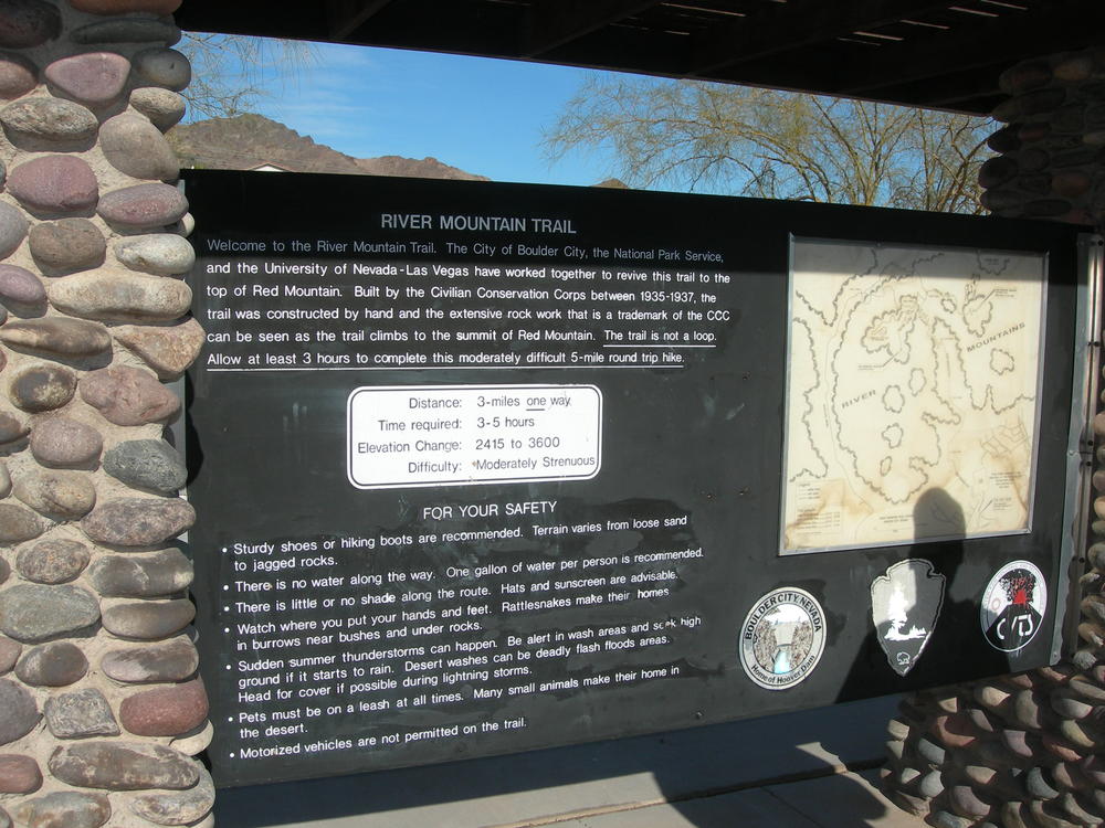
The Mountain Lake Park and Trailhead provides access and serves as a connecting hub to three trail systems including the River Mountains Loop Trail.

River Mountain Trail…circa 1935-1937


Kiosk trail head sign at River Mountain Trail Head

The River Mountain Trail often times gets confused with the River Mountains Loop Trail and visa versa.  That is because they are both trails in the River Mountains.   The original River Mountain Trail was built by the Civilian Conservation Corps (CCC) between 1935-1937 during the time of Hoover Dam construction.  The trail head is located just downhill on Nevada Hwy past the National Park Service warehouse. The trail head was built and developed by the City of Boulder City, the National Parks Service, the University of Nevada Las Vegas who worked jointly to revive this trail to the top of Red Mountain.  The trail was constructed by hand and has extensive rock-work that is a trademark of the CCC which can be seen as one hikes to the summit of Red Mountain.  This trail is not a loop, but 3-miles one way making for a six-mile round trip.  Allow 3-5 hours to make the hike and enjoy the views.  You will experience an elevation change from 2415 to 3600 feet.  The Park Service has rated this hike as Moderately Strenuous. 


With the completion of the River Mountains Loop Trail through Boulder City late 2009/early 2010 this trail head became a shared trail head for both trails.  As yet no map or kiosk for the loop trail has been installed but the trail head is at Mile Marker 30.

This trail head is primitive – no water or restrooms.


Bicycling Routes, Lanes, Trails on Google Maps “How to Find”

April 2010 – How do I find the River Mountains Loop Trail?  Where are the trail heads? Where are there connecting trails and bike routes or lanes?  Where can I see photos taken along the trail? Google Maps has the answer.  I have enclosed a power point presentation which hopefully walks you through the process.  It is still a work in progress, but it gets you out there on the trail.  Once you master this you can go anywhere across the country and try it out.

Step one:  get to Google and select Google Maps.  Step Two: Select Satellite (my preference)  Step three: search maps for ‘River Mountains Loop Trail, Henderson, Nv. 89015’    Step four:  select more and on the drop down menu click on photos & bicycling; green lines should appear indicating trails and bike routes along with photo icons.

Now the fun begins. To view the photos, place your cursor over a photo and click; photo opens with title and owner; click on by nevhiker(owner) or view in Panoramio to see larger photo and more…

Trail Heads:  To find trailheads and other points of interest go to the “New” button in green, click and a drop down of new features appears; scroll down and enable “What’s Around Here?” Little dots and buttons appear along with a listing down the left side of your screen.  you can move around the map and along the green trail and different points of interest and trail heads will appear.  click on a lettered button or a round dot to see what is there. The example in the Powerpoint (slide three) shows trail head information for “Historic Railroad & River Mountains Loop Trailhead“.  From this pop up you can get directions, link to web site, read reviews or write them, plus get additional information(slide 4).

Finally try it out and experiment  on your own and enjoy.  It is a great trail tool. Reminder Google is Beta testing this feature so it could change at anytime or even just go away.

Link  Powerpoint:  RMLT google maps – trails-bicyling march 2010

Google maps Bike Routes & Trails

Recent Blog Posts

Dogs on the Trail

Las Vegas Hiking Trail Featured in Article

Las Vegas Hiking Trail Featured in Article

Pacifica trail head Boulder City on the new trail website.

New Trail Website

Be Sure to Visit

Latest Posts on Facebook

Comments Box SVG iconsUsed for the like, share, comment, and reaction icons
Author Avatar
River Mountains Loop Trail
2 months ago

www.facebook.com/share/p/1Hz7o2W4xo/ ... See MoreSee Less

Link thumbnail

Register for a Smart Cycling Class | League of American Bicyclists

bikeleague.org

Post Title
View on Facebook
· Share
Share on Facebook Share on Twitter Share on Linked In Share by Email
View Comments likes 0 Shares: 0 Comments: 0

0 CommentsComment on Facebook

Author Avatar
River Mountains Loop Trail
3 months ago
Come and join us on

Come and join us on March 14th! ... See MoreSee Less

View on Facebook
· Share
Share on Facebook Share on Twitter Share on Linked In Share by Email
View Comments likes 3 Shares: 0 Comments: 0

0 CommentsComment on Facebook

Author Avatar
River Mountains Loop Trail
4 months ago
Love our trail!

Love our trail!🎙️ New Podcast Episode Alert 🚨

Ever wondered what it takes to maintain 34 miles of paved paradise? 🌵

In this episode of The Best Dam Podcast, Howard is joined by Paul Grube, President of the River Mountains Loop Trail Partnership. Paul takes us behind the scenes of one of Southern Nevada’s most beloved outdoor assets—the River Mountains Loop Trail.

www.bouldercitychamber.com/connecting-communities-34-miles-of-cycling-hiking-and-history-on-the-r...

From its "happy hour" beginnings in the late '90s to becoming a world-class 34-mile loop connecting Boulder City, Henderson, and Lake Mead, this trail is a testament to community vision.

Highlights include:

🐢 The funny story of the "moving rock" (spoiler: it was a tortoise!).
🐑 Tips for spotting bighorn sheep and other local wildlife.
🛠️ How the Partnership acts as the "eyes and ears" to keep the trail safe.
🚲 Why you don’t even need your own bike to get started.

Whether you’re a hardcore cyclist or just love a morning stroll, you won’t want to miss Paul’s insights on this local treasure! ☀️
... See MoreSee Less

View on Facebook
· Share
Share on Facebook Share on Twitter Share on Linked In Share by Email
View Comments likes love 6 Shares: 1 Comments: 3

3 CommentsComment on Facebook

Load more

View Full-Sized