River Mountains Loop Trail

Facebook icon

  • Home
  • About
  • Trailheads and Maps
    • Trailheads in Boulder City
    • Trailheads in Henderson
    • Trailheads in Lake Mead NRA
  • History
    • Geology of the River Mountains
    • A -Desert Tortoise – Do’s & Dont’s
    • Keep It Clean
  • Blog
    • Recently on Facebook
  • Contact
    • Contact List
  • Donate

Trailheads in Henderson

River Mountain Loop Trailheads in Henderson, NV are featured on this page. All are within the boundary of the city.

Henderson, NV Trailhead Map

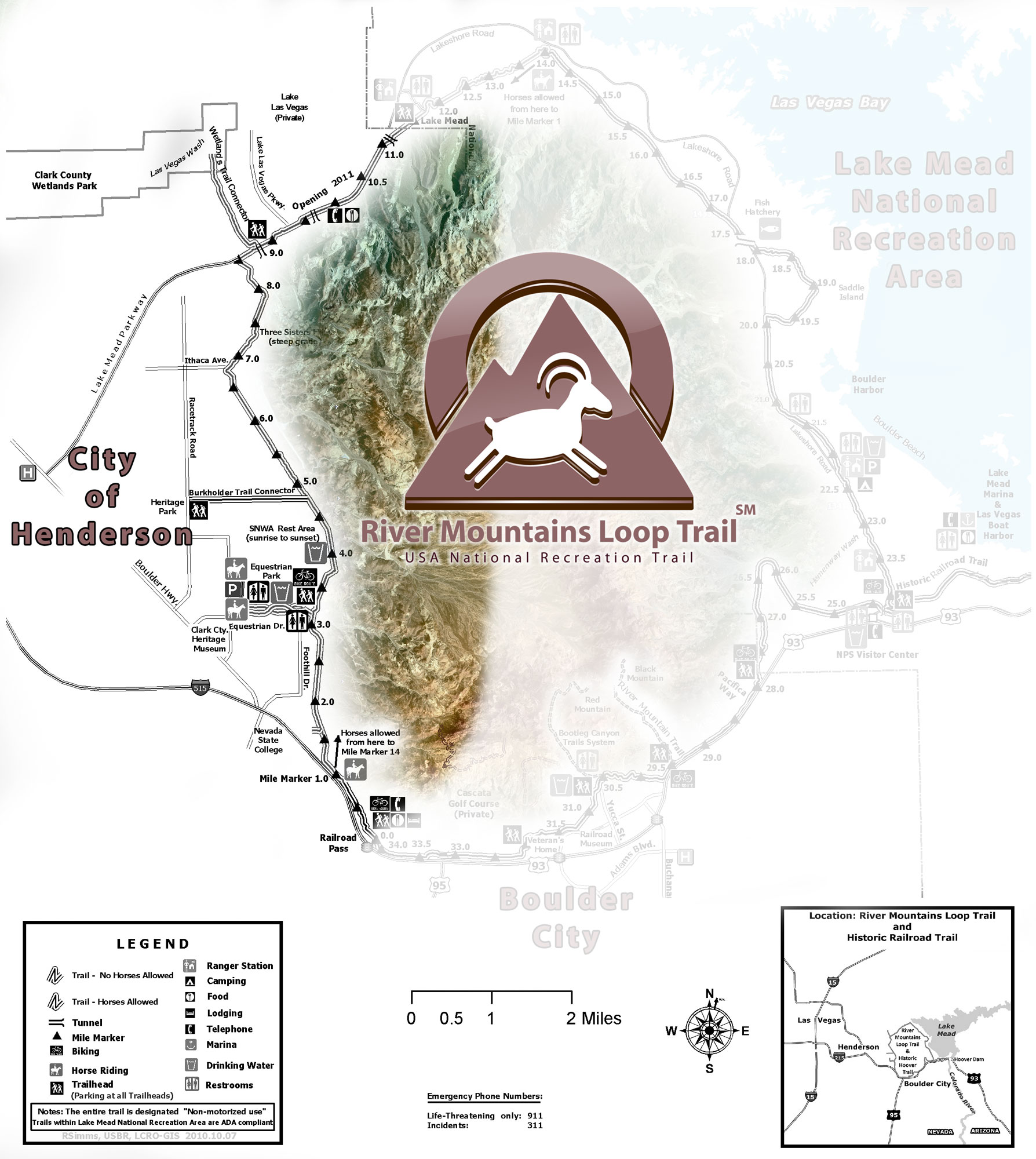
Click map for larger views.


Equestrian Park – Trailhead

RMLT Equestrian Park TH 2-05-14

Equestrian Trailhead

1699 Equestrian Drive at Foothill Drive
Henderson, NV 89002

To find Equestrian Park Trailhead from Las Vegas: Take I-515 to the Horizon Drive exit, at the top of the exit, turn left (east) on Horizon Drive and go( 1-1/2 miles) to Boulder Highway, turn right (south) on Boulder Highway, go south one block to the next traffic light (Equestrian). At the traffic light turn left (east) on Equestrian Drive and take it to the end of the street. This is the trailhead. The building is a bathroom.

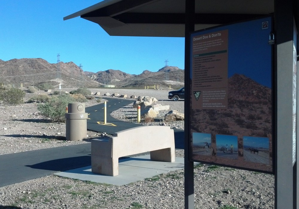
On the way to the trailhead you pass by Equestrian Park. The park serves as a secondary trailhead and also has Equestrian facilities for horses to access the RMLT.


Mountain Lake Park – Trailhead

1020 Golda Way, Henderson, NV  89011

Mountain Lake Park Trailhead

Mountain Lake Park Trailhead

This park and trailhead is located in Henderson, NV. and best accessed by taking Lake Mead Parkway from Boulder Highway East to Golda Way, just one mile west of Lake Las Vegas Parkway. This park – trailhead offers parking, restrooms, picnic tables, kids discovery area, water, trash, Shade, and Equestrian facilities. The trailhead also serves as a hub or connecting point to three (3) different trails including the River Mountains Loop Trail. The other trails are the Wetlands Connector Trail and the Lake Mead Parkway Trail. The new Vegas Valley Rim Trail(VVRT) will also connect at this park once complete.


Silverman Connector – Access Point

Silverman Connector Trail , Henderson, NV.

Silverman Connector Trail , Henderson, NV.

This connector trail is located in Southeast Henderson, Nevada. From the intersection of Wagonwheel and Boulder Highway head south on Old Vegas Drive to it’s intersect with Foothills Drive. ( Paradise Hills Parkway). Park legally along road way. No facilities.

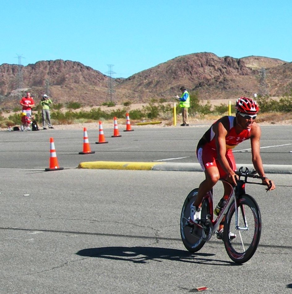
The Silverman Connector is named after the Silverman Triathlon which has used this connector for many years during the Fall Triathlon event. There are no signs other than the yellow posts at the entry to the trail on the east side of the intersection.

Recent Blog Posts

Dogs on the Trail

Las Vegas Hiking Trail Featured in Article

Las Vegas Hiking Trail Featured in Article

Pacifica trail head Boulder City on the new trail website.

New Trail Website

Be Sure to Visit

Latest Posts on Facebook

Comments Box SVG iconsUsed for the like, share, comment, and reaction icons
Author Avatar
River Mountains Loop Trail
6 days ago

We are EXTREMELY short on survey responses for statewide outdoor recreation needs!

Please click the link below to take the Statewide Comprehensive Outdoor Recreation Plan (SCORP) survey (about 5-7 minutes). The SCORP is a 10-year plan that establishes priorities to address unmet needs for public outdoor recreation land throughout the state. This is vital information for continued funding and outdoor recreation access in Nevada!

... See MoreSee Less

Link thumbnail

2027-2036 Nevada Statewide Comprehensive Outdoor Recreation Plan (SCORP) | State Parks

parks.nv.gov

Find your next adventure at parks.nv.gov
View on Facebook
· Share
Share on Facebook Share on Twitter Share on Linked In Share by Email
View Comments likes 2 Shares: 1 Comments: 0

0 CommentsComment on Facebook

Author Avatar
River Mountains Loop Trail
4 months ago
The River Mountains

The River Mountains Loop Trail detour will begin 8/4/25 and last for 30 days to install waterline adjacent to the RMLT between reservoirs R7 &R12 (approx. 2,500 feet) along with two trail crossings. The waterline trench is within a few feet of the edge of trail and would pose a hazard to the trail traffic being in close proximity to the open trench and equipment. Several options were considered by the City of Henderson, and the attached detour was selected as the safest and easiest physically option to the public while keeping the trail functional and on similar pavement. ... See MoreSee Less

View on Facebook
· Share
Share on Facebook Share on Twitter Share on Linked In Share by Email
View Comments likes wow angry 15 Shares: 5 Comments: 11

11 CommentsComment on Facebook

Author Avatar
River Mountains Loop Trail
5 months ago
RMLT DETOUR! The Lak

RMLT DETOUR! The Lakemoor development will be doing work in the near future that affects the trail. Attached is the detour route that has been approved. The work is anticipated to be at least 2 months (60 days), and the work is anticipated to start on July 21, 2025. ... See MoreSee Less

View on Facebook
· Share
Share on Facebook Share on Twitter Share on Linked In Share by Email
View Comments likes wow angry 9 Shares: 0 Comments: 5

5 CommentsComment on Facebook

Load more

View Full-Sized