River Mountains Loop Trail

Facebook icon

  • Home
  • About
  • Trailheads and Maps
    • Trailheads in Boulder City
    • Trailheads in Henderson
    • Trailheads in Lake Mead NRA
  • History
    • Geology of the River Mountains
    • A -Desert Tortoise – Do’s & Dont’s
    • Keep It Clean
  • Blog
    • Recently on Facebook
  • Contact
    • Contact List
  • Donate

Hike to Liberty Bell Arch

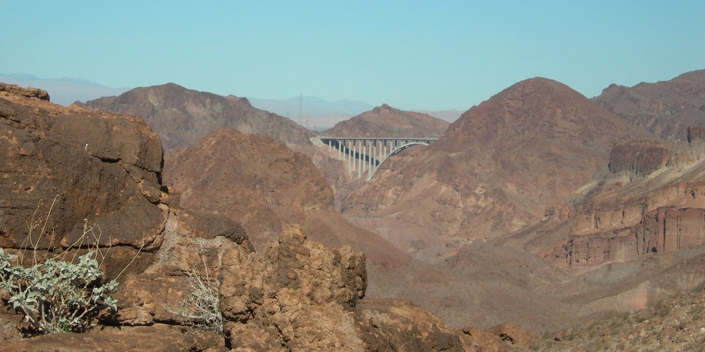
On January 17th, 2011 some good friends and I went on a hike to the Liberty Bell Arch on the Arizona side of the Colorado River below Hoover Dam.  The 2.5 mile hike route provided several views of the new O’Callaghan – Tillman Memorial Bridge located upstream about 3 – miles.

O’Callaghan – Tillman Memorial Bridge 3.5 miles downstream 11711

 The Bridge was also visible from the Liberty Bell Arch.  We could only get 1/2 the bridge into the photo due to the angle of the river and we would have to be flying out over the river to get the full bridge in view.

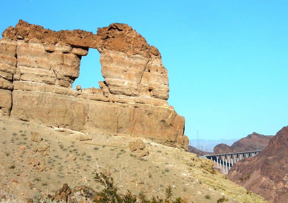
Liberty Bell Arch & Bridge in Back ground…3.5 miles north

This was my first crossing of the bridge since its opening in November 2010. Speed was 55 MPH and we just zipped across at 8:00 a.m. in the morning.  You can not see the Colorado River or Hoover Dam while driving across the dam, so do not try.  On the Nevada side of the river you have to take the Hoover Dam Access road(the old road) down to either the new visitor parking at the bridge to walk out on the bridge on the Hoover Dam side only; or drive on down to parking at the dam in order to get photos of the new bridge and visit the dam. There are no bike lanes on the bridge for riding across, but you can walk across on the walkway.

To ride a bike to the Hoover Dam or Bridge viewing one can access via the Historic Railroad Trail at Alan Bible Visitor Center located approximately 4.0 miles west of Hoover Dam.  This ride will provide great views of Lake Mead while passing through five large railroad tunnels on the way out to the dam. The trail is wide and the tread is native material with a very gentle grade until the very end. The last 1/4-mile drops down to an access point to the Hoover Dam visitor center where you can either walk the bike down a Switchback walkway or park and lock at the top.  The Bureau of Reclamation has not yet made a direct connection from the Historic Railroad Trail to the Bridge viewing area, so be careful crossing roads.

LIBERTY BELL ARCH TRAIL: Link to article by Deborah Wall in The View – http://www.viewnews.com/2011/VIEW-Jan-11-Tue-2011/CentennialHills/41270190.html   if you clip this article and follow it, you will find yourself at the Liberty Bell Arch on the Colorado River.

« River Mountain Trail…circa 1935-1937
O’Callaghan – Tillman Bridge at Hoover Dam »

Recent Blog Posts

Dogs on the Trail

Las Vegas Hiking Trail Featured in Article

Las Vegas Hiking Trail Featured in Article

Pacifica trail head Boulder City on the new trail website.

New Trail Website

Be Sure to Visit

Latest Posts on Facebook

Comments Box SVG iconsUsed for the like, share, comment, and reaction icons
Author Avatar
River Mountains Loop Trail
2 weeks ago

We are EXTREMELY short on survey responses for statewide outdoor recreation needs!

Please click the link below to take the Statewide Comprehensive Outdoor Recreation Plan (SCORP) survey (about 5-7 minutes). The SCORP is a 10-year plan that establishes priorities to address unmet needs for public outdoor recreation land throughout the state. This is vital information for continued funding and outdoor recreation access in Nevada!

... See MoreSee Less

Link thumbnail

2027-2036 Nevada Statewide Comprehensive Outdoor Recreation Plan (SCORP) | State Parks

parks.nv.gov

Find your next adventure at parks.nv.gov
View on Facebook
· Share
Share on Facebook Share on Twitter Share on Linked In Share by Email
View Comments likes 2 Shares: 1 Comments: 0

0 CommentsComment on Facebook

Author Avatar
River Mountains Loop Trail
5 months ago
The River Mountains

The River Mountains Loop Trail detour will begin 8/4/25 and last for 30 days to install waterline adjacent to the RMLT between reservoirs R7 &R12 (approx. 2,500 feet) along with two trail crossings. The waterline trench is within a few feet of the edge of trail and would pose a hazard to the trail traffic being in close proximity to the open trench and equipment. Several options were considered by the City of Henderson, and the attached detour was selected as the safest and easiest physically option to the public while keeping the trail functional and on similar pavement. ... See MoreSee Less

View on Facebook
· Share
Share on Facebook Share on Twitter Share on Linked In Share by Email
View Comments likes wow angry 15 Shares: 5 Comments: 11

11 CommentsComment on Facebook

Author Avatar
River Mountains Loop Trail
5 months ago
RMLT DETOUR! The Lak

RMLT DETOUR! The Lakemoor development will be doing work in the near future that affects the trail. Attached is the detour route that has been approved. The work is anticipated to be at least 2 months (60 days), and the work is anticipated to start on July 21, 2025. ... See MoreSee Less

View on Facebook
· Share
Share on Facebook Share on Twitter Share on Linked In Share by Email
View Comments likes wow angry 9 Shares: 0 Comments: 5

5 CommentsComment on Facebook

Load more

View Full-Sized